COMPREHENSIVE PLAN
Comprehensive planning is a process that determines community goals and aspirations in terms of community development. It acts as the foundation for all land use decisions, defines the community’s vision, provides guidelines for development, and establishes goals and objectives for the next several years. The comprehensive plan for the Town of Gibraltar is an important long-range planning and policy tool to assist with decision-making from 2023 through 2043. The purpose of this plan is to guide development by reflecting the community's shared vision and priorities for future growth.
In September 2022, the Town of Gibraltar started work on a comprehensive plan, in accordance with Wisconsin's Comprehensive Planning Law (Wis. Stats. 66.1001). Prior to the establishment of this document, the Town of Gibraltar last adopted its comprehensive plan in 2010. Given existing statutory requirements, the Town was ready for a plan update. However, the objective of this plan is intended to address more than state requirements. It is meant to ensure its policies guiding development and funding decisions align with the community's current goals and vision for growth.
Until the next update in 2043, this current plan should be consulted when the Town makes decisions concerning land use and other issues impacting the development of the Town.
Town of Gibraltar Comprehensive Plan
View the comprehensive Plan Online
In order to allow the public instant access to this comprehensive plan, the Bay-Lake Regional Planning Commission established an ArcGIS Online Story Map. The Story Map is an interactive version of the Town's plan that may be updated on an as needed basis. The ArcGIS Online Story Map for the Town of Gibraltar Comprehensive Plan is accessible via the link below.
Gibraltar Bike and
Pedestrian Plan
Similar to the Town's Comprehensive Plan, the Gibraltar Bike and Pedestrian Plan is designed to guide the development of community's shared‐use paths, determine on‐street facilities, provide design guidelines and
policies for facilities, and highlight funding opportunities related to bike and pedestrian transportation.
This plan should be updated every ten years to reflect the needs of the community and progress that has been made toward implementing the plan’s goals.
Gibraltar Bike and Pedestrian Plan
Door County Bike & Pedestrian Plan
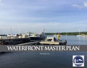
Waterfront Master Plan
The purpose of the Plan is to identify enhancements to Fish Creek’s waterfront areas with a focus on the Town Dock, boat launches, Town Beach, and Fish Creek. It provides a blueprint for the Town of Gibraltar and its public and private partners to invest in the future.